

Malham Tarn and Great Close Hill
No trip to Malham would be complete without a visit to its famous tarn! This walk also heads up Great Close Hill which overlooks it as a bit of a change to the usual circular.
Located above the village of Malham, the tarn is often far quieter than the walks in the village itself!
Have you walked around Malham Tarn?
A stunning place to visit, this National Trust owned area is surrounded by rolling moorland, and feels a million miles away from the bustle of Malham itself.
As an alternative to the longer well-known circular walk around Malham Tarn, this shorter wander takes in the summit of Great Close Hill, crowned by its historic cairn. This mini peak is found next to the tarn. Not a big ‘un, so a good one for littler legs and the views from the top across the tarn are stunning. Totally underrated, this route is much quieter than any other Malham walk!
Tempted?

Buy Me a Coffee
Make a Donation
Thank you for taking the time to have a look at my website and for reading this now!
I set up the Reluctant Explorers and maintain the website and attached social media accounts in my spare time, around mum-life and two jobs. It was designed to provide access for parents to free resources to help get more families outside and exploring in nature. These walks have all been created by myself and the kids and we have walked each one ourselves (and re-walk them regularly to keep the information as up to date as we can).
If you would like to support us and can afford a few pennies, you can make a donation to our ‘Buy Me a Coffee’ page. Simply tap the button below to head there!

Sitting at the edge of the cairn looking towards the tarn and Fountains Fell beyond.
Walk details for Malham Tarn and Great Close Hill
Distance: 3 miles
Terrain: Mainly clear paths, but the route to the top of Great Close hill isn’t well walked, so isn’t as clear as some of the other Malham routes. Some ascent (300ft). There is a little more exploring on Great Close Hill, which is on open access land, and a detour to the mahoosive ancient cairn is well worth it! This is one where navigation skill and a map are a must.
Parking: Malham Tarn Car Park
Public Transport: Whilst the village of Malham is accessible by bus, the start point for this walk is not easily accessible by bus.
Dog Friendly? Yes. Whilst some of the nature reserve is not accessible to dogs, this part is!
Location: Malham, The Yorkshire Dales
Map: OS OL02 Yorkshire Dales Southern and Western
What 3 Words: camps.ballooned.richest (car park and starting point)
Toilets/ Baby Change: Nearest is Malham Village
Nearest Cafe/ Amenities: Malham Village

Map reading by the water of the tarn
How to get to Great Close Hill from Malham Tarn
Directions:
From the car park , take the wide grassy track heading in the direction of the water. The path takes you to the edge of the tarn and then follows the water before gradually bending round to the right and meeting the edge of the woodland to your left. Follow this path, until you reach a gate onto a wide stony track, which roughly follows the perimeter of the tarn (but the water is now at a distance).
Walk along the stony track as far as the edge of more woodland (these are the woods surrounding Malham Tarn Field Centre). Don’t enter the woodland, but instead turn right up the signposted path to your right. You will begin to climb at this point. The hill to your right as you ascend is Great Close Hill and as you reach the saddle, where the ground levels out a little, you need to turn off to the right . There is no ‘public footpath’ marked on the map, but you are on open access land where you have the ‘right to roam’ and in reality, there is a trodden grassy path which leads you to the summit. You will be heading in a south-eastern direction isfyou fancy getting the compass out!
Once at the top you’ll see the huge cairn. Be careful not to disturb any of the rocks, you are actually at an ancient burial mound and the site is protected monument. From here, you’ll get cracking views over the tarn and the surrounding fells! At this point you have options. The path beyond this point is faint and requires good navigation skills to use the contours of the hill to descend. Be careful not to head right (and therefore south west) at the cairn, as you’ll find yourself walking towards the scar, which has a steep drop. Instead, keep straight on and if in doubt, left using the gradient of the hill to safely get down. There is a faint path, but one that’s not 100% obvious. A true adventure! In ground nesting bird season, do stick to the trodden path (March to July).
If you aren’t keen on the idea of wandering wild and free, simply retrace your steps to the tarn. If you fancy a little more of a wander, you can enter the woods around the field centre, there’s a little information centre and some chainsaw sculptures to spot too.
If you’ve soldiered onwards, then at the bottom of the hill, you’ll meet a wide surfaced track, that provides access to the farmhouses beyond. Turn right onto this, (it’s a public bridleway) and head over the cattle grid through the dry stone wall. You will see a little plantation of trees to your right. After the cattle grid, turn right and follow the line of the wall to lead you back to the track you used at the start of the walk to go to Malham Tarn. Here, head back to the car park.
Last walked February 2024

Approaching the cairn at the top of Great Close Hill.
What’s cool for kids on this walk?
💦 You are NOT able to paddle or swim in the Tarn as it is a protected nature reserve, but you can take a little wander to water sinks, which is where the beck disappears into the ground, before reappearing at the base of Malham Cove. There you could have a paddle if you fancied it, and it is only a 10 minute walk.
✨ Malham Tarn is actually quite unique to this part of the Dales. Located in limestone territory, usually the permeable rock just lets the water sink into the ground, which is why there really aren’t many natural tarns around. However, Malham is unique, because when it was formed during the Ice Age, it actually formed on top of a watertight layer of slate, which means the water doesn’t sink! Because it was so unique to the area, it became a bit of a hotspot for wildlife and for early settlements, and archaeological evidence has been found of early human life here. Now, it is a nature reserve, and if you fancy extending the walk here, you can head all the way around it! (Source yorkshiredales.org.uk)
🦆 There are loads of birds, animals and plant life to spot here with it being a nature reserve and all we’ve even spotted deer.
🐇 The Malham Tarn Field Centre is found at the head of the tarn and is the hub of the nature reserve, from here, you can actually borrow a tramper which makes parts of the tarn wheelchair accessible. If you end up retracing your steps, it’s worth going and checking out the chainsaw sculptures on the far side of the centre.
🌳 If you need some help with the walking whinges, then check out our walking games! Or perhaps downloads a scavenger hunt!

Helpful Information!
⭐ We hope you enjoy our walks, but please exercise common sense as routes can change with the weather conditions and seasons! The routes have been walked by our own two feet, but you know your own limits. Always take a back-up map, don’t rely on GPS alone, wear appropriate clothing for the weather and take adequate snacks and refreshments with you (although as a parent, I know you already know that bit!)
⭐ Leave no trace! Take nothing away and leave nothing behind, take all rubbish home with you.
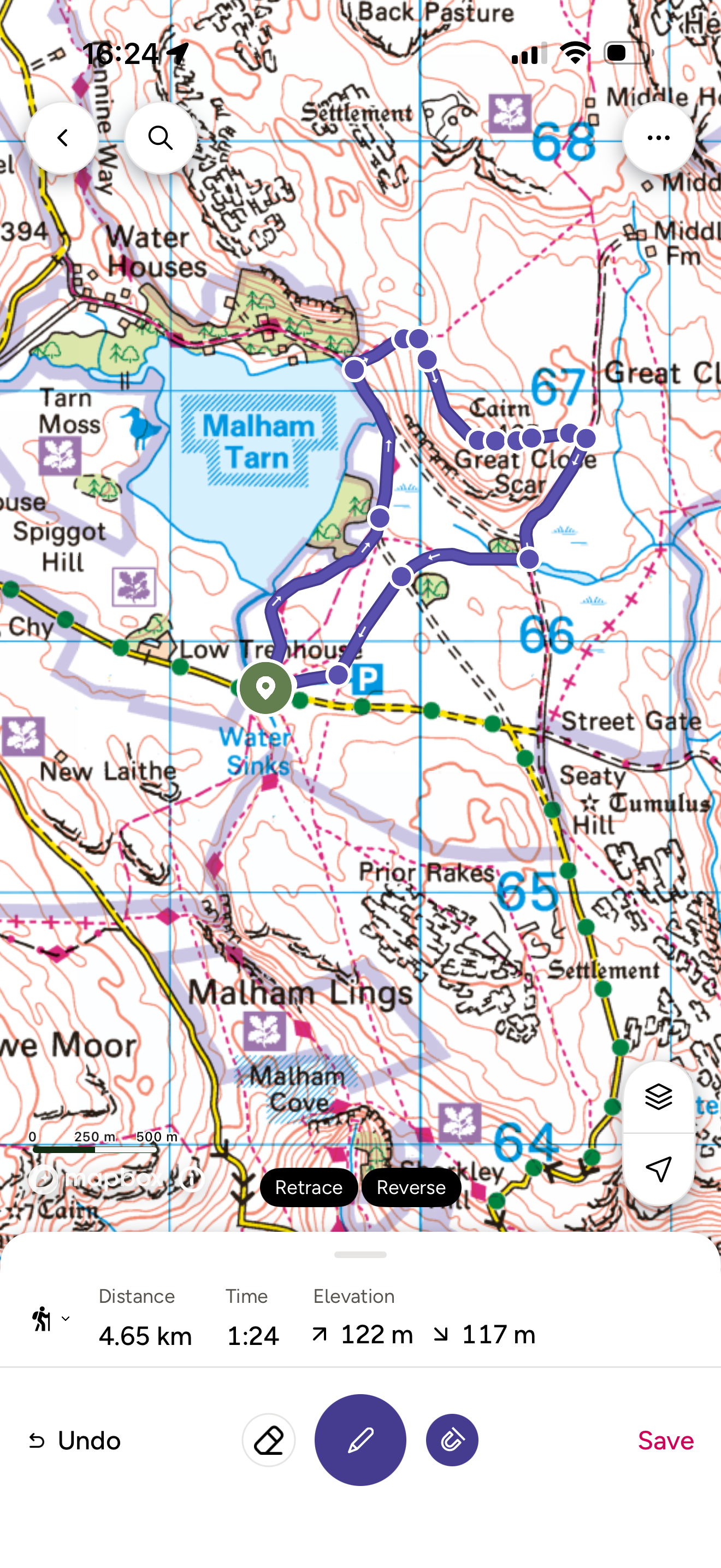
Want to grab the route?
You will need an Ordnance Survey OL02 Explorer map for this walk. Grab one from the Ordnance Survey online shop!
(Always carry a back up map and know how to use it)
Image is Copyright of Ordnance Survey
(Affiliate Link as an Ordnance Survey Champion)

More Malham walks please?
Malham is admittedly one of the busiest parts in the Yorkshire Dales, but it does have a lot of beautiful places!
Including Janet’s Foss waterfall!
Want to do the walk? Then head to our walk description!
Scroll using the arrows for all our Family Friendly Walks
-
![Swimming in Janet's Foss Yorkshire Dales]()
Waterfall Walks
-
![Malham cove walk for kids]()
Pushchair Friendly
-
![Pinhaw Beacon trig point walk near Skipton]()
Peak Bagging Walks
-
![The Park at Greenhow Nidderdale]()
Walks with Play Parks
-
![Gordale Scar in Malham Yorkshire Dales]()
Organised by Location
-
![Walking in the woodland in Wensleydale]()
Woodland Walks
-
![Playing on the shore of Embsay Reservoir Yorkshire Dales]()
Reservoir Walks
-
![The ruins of Bolton Abbey]()
Bolton Abbey Estate Walks
-
![Leaping over the stile at Almscliffe Crag]()
Walks Under 2 Miles
-
![Child walking into a pub in Appletreewick]()
Walks with Pubs and Cafes





Follow us for up to date Outdoors Adventures!
We live and BREATHE the Yorkshire Dales outdoors life!
BEEN INSPIRED? Tag us @reluctantexplorers
Come follow our journey over on Instagram and Facebook where you’ll find up to date walk info, breaking news on Yorkshire Events, new Yorkshire Dales wild swim spots, climbing, caves and more!


Follow us on Social Media for all the up to date info: @thereluctantexplorers

Leave No Trace
The Yorkshire Dales is our home, and the home of so many others who care deeply about this beautiful space.
Should you visit, make sure to:
Take home anything you bring, leave no rubbish behind.
Make the world a better place by picking up any rubbish you see, even if it isn’t yours.
Leave everything else as you found it.