
Muker Circular
This mini wander is the perfect circular for little legs.
Starting and ending in the gorgeous village of Muker in Swaledale, the views are to die for! Plus the walk will take you to a riverside picnic and paddle spot too and there’s a pub at the end (that’s for the grown ups!)
Have you ever been to Muker?
A stunning village located in the northernmost reaches of the Yorkshire Dales National Park. Yet for such a tiny village it’s got some pretty interesting associations! In fact the King himself wears gloves handmade in Muker… I Know. It’s reyt la-dee-da!
But royal associations aside, Muker is a STUNNING place to be in the Dales. Surrounded by the glorious high moorlands of Swaledale, this pretty village is a great place to begin and end a walk, with a fabulous local pub serving tasty grub. So of COURSE you want to walk it!
This circular takes you to a fabulous picnic and play spot at Rampsholme Bridge. Oh, and there are fossils. You’ll be falling over them! (Hopefully, not actually!)
Buy Me a Coffee
Make a Donation
Thank you for taking the time to have a look at my website and for reading this now!
I set up the Reluctant Explorers and maintain the website and attached social media accounts in my spare time, around mum-life and two jobs. It was designed to provide access for parents to free resources to help get more families outside and exploring in nature. These walks have all been created by myself and the kids and we have walked each one ourselves (and re-walk them regularly to keep the information as up to date as we can).
If you would like to support us and can afford a few pennies, you can make a donation to our ‘Buy Me a Coffee’ page. Simply tap the button below to head there!

One of the Muker meadows on the way to the bridge in August. One day we WILL manage to see the wildflower meadows!
Walk details for Muker Circular
Distance: 1.5 miles
Terrain: Easy footpaths, well signposted, little ascent 100 feet. Make sure you stick to the footpaths through the meadows, there are stunning protected wildflowers in the Spring/ early Summer.
Parking: Muker village centre, vergeside or the car park by the bridge into the village. It can get busy in the wildflower months, so have a plan B. Why not try the Keld Waterfalls, Gunnerside, or Reeth stepping stones!
Public Transport? There is a bus service running to Muker, but this is subject to a seasonal timetable, so check out the Dales Bus website for more information.
Dog Friendly? Yes but there is grazing cattle on this walk.
Location: Muker, Swaledale Yorkshire Dales National Park
Map: OL30 Yorkshire Dales Northern and Central areas affiliate link as an Ordnance Survey Champion
What 3 Words: parking - bouncing.couple.scrambles
Toilets/ Baby Change: Muker
Nearest Cafe/ Amenities: Muker - try the village store and the Farmers Arms
How to walk to Rampsholme Bridge from Muker
Directions (to be used alongside a map)
Beginning at the car park, head into the centre of the village to the Muker Village Store. To the right of the building, there is a narrow residential road, head up this. You will see the little church on your right hand side. Continue straight on through the village until you reach the lane leading out of the buildings on the northernmost point.
You will see a grit bin, and a footpath sign next to it pointing out of the village. Take this path. It leads to a further footpath sign and follow the path as it heads through several fields until it reaches the river.
Here, on your right, you will see Rampsholme Bridge. If the conditions are right, you can get down to the edge of the water and fossil hunt and if you cross the bridge there are some excellent picnic spots on the far bank. Once you have explored, head back over the bridge and then turn right. Head along the edge of the water for a short distance, keeping it on your right. (If you picnic take all your rubbish home)
At the farm building after around 300 yards turn of the main track and take the path that heads left around the back of the building and onto a walled track heading back in the direction of Muker.
This will lead you all the way back into the village where you began.
Last walked in August 2025

One of the fossils found in the river.
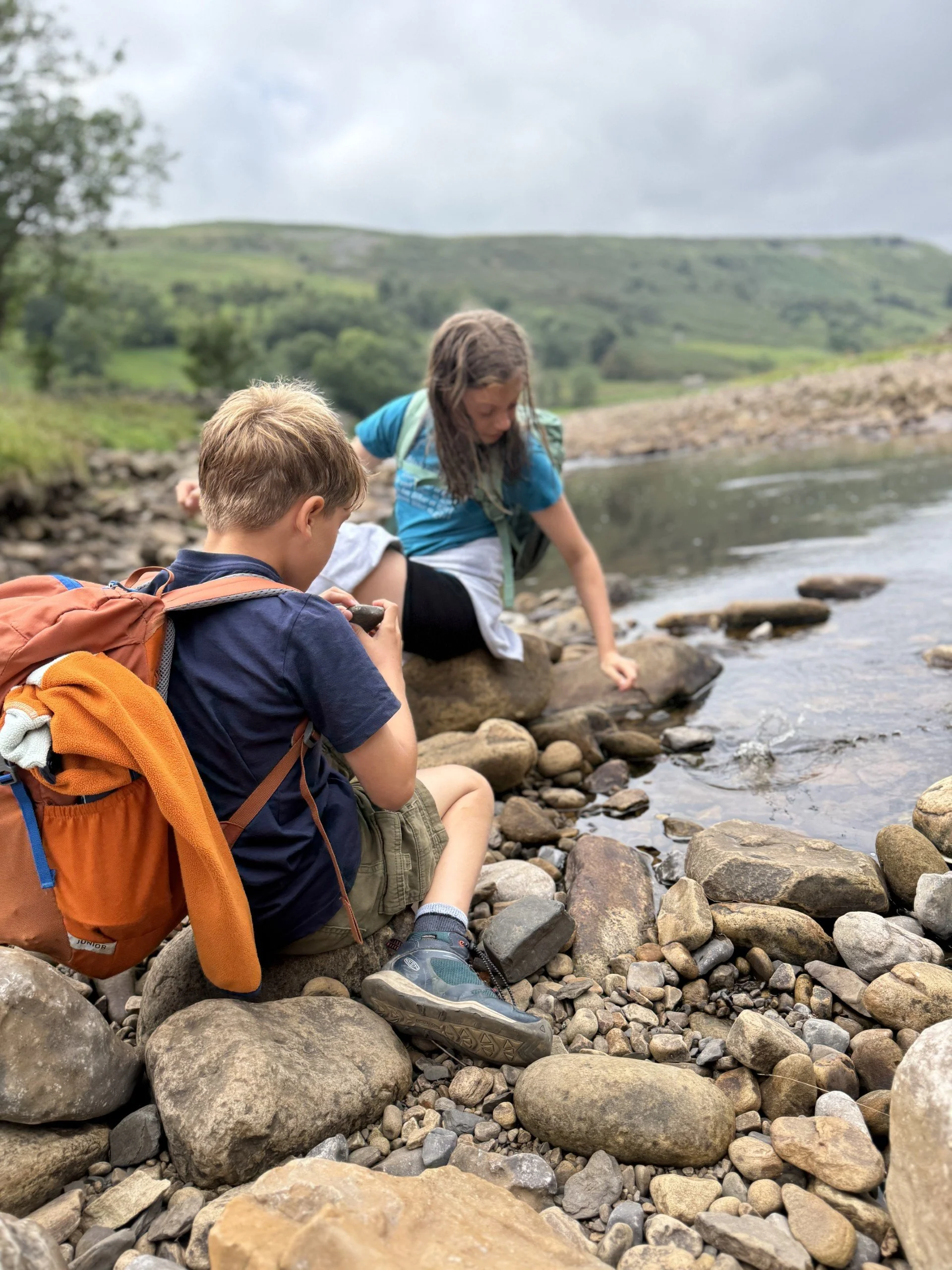
Fossil hunting by the side of the river
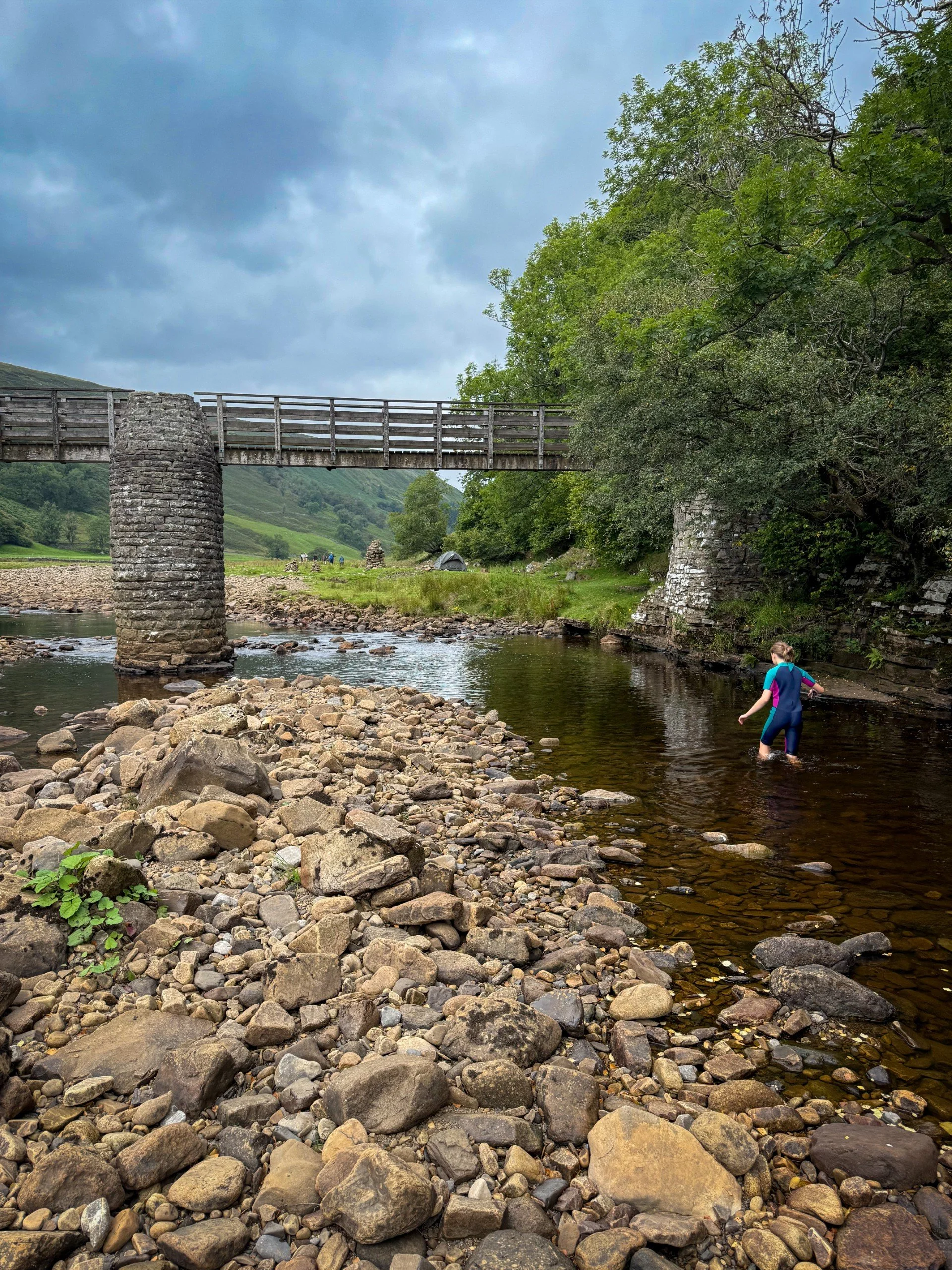
A little cheeky paddle in the water at the bridge. This was after a very dry Summer, the river is very reactive so will change after rain.
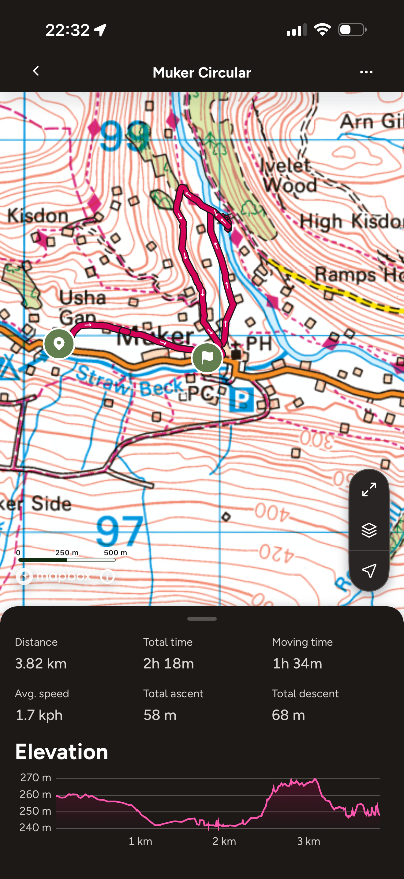
The route from Muker to the bridge
What’s cool for kids on the Muker Circular?
It’s a short one, but for 1.5 mile you’ll get
💦 Splash and paddle spots. This is a river, so the the beds shift and change year by year. If you choose to play by the river, make sure you are familiar with the RLSS Summer safety code.
If you want any more information about Wild Swimming with Kids, check out our blog which has links to expert advice.
🥪 Picnic spots by the river ( LEAVE NO TRACE! There is no such thing as the litter fairy and to be honest if you come and leave your rubbish behind, you are not welcome to visit this place)
🍇 There are blackberry picking spots too in the late summer.
🌳 Want more ideas to beat the walking whinge? Why not check out our walking games? Or you can download one of our free printable scavenger sheets.

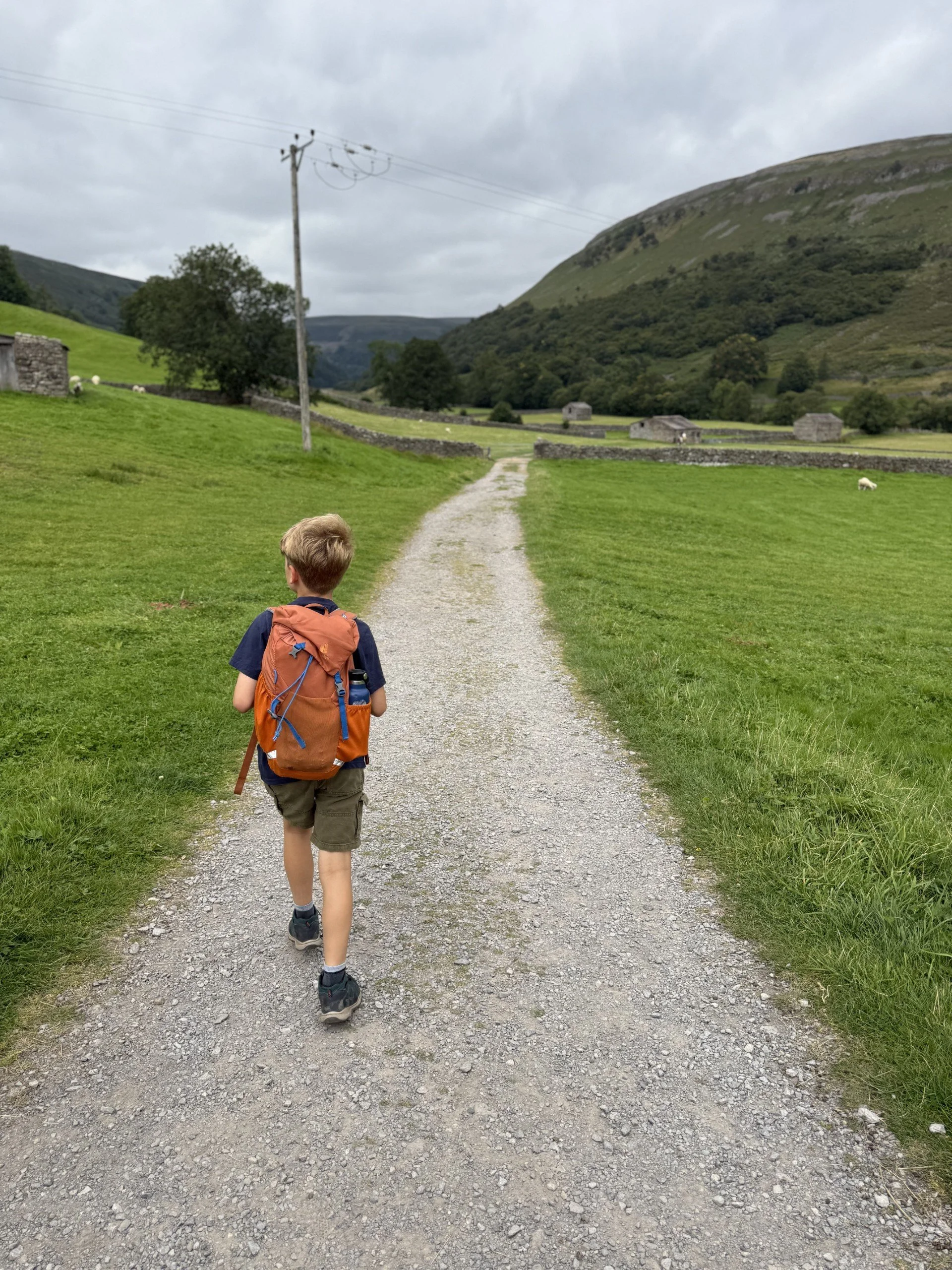
TO THE BRIDGE! Look at the enthusiasm!
Helpful Information!
For more helpful information head to our safety tips and advice page.
⭐ We hope you enjoy our walks, but please exercise common sense as routes can change with the weather conditions and seasons! These walks are intended as a guide only and are undertaken at your own risk. The routes have been walked by our own two feet, but you know your own limits. If in doubt, turn back. Always take a back-up map, don’t rely on GPS or your phone alone, wear appropriate clothing for the weather and take adequate snacks and refreshments with you (although as a parent, I know you already know that bit!)
⭐ Leave no trace! Take nothing away and leave nothing behind, take all rubbish home with you.
⭐ If you choose to paddle, be aware of bio security. Always wear clean dry water shoes (if worn) to avoid cross contamination of species between watercourses, this is a particular issue in the Yorkshire Dales, to help protect the white clawed crayfish.
⭐ If you decide to paddle, be aware that wild water can be dangerous, and water levels will vary season to season. Always supervise children around water. Check out the safety information on the Royal Life Saving Society website.

Want to grab the route?
You will need an Ordnance Survey OL30 Explorer map for this walk. Grab one from the Ordnance Survey online shop!
(Always carry a back up map and know how to use it)
OR if you have the OS Maps app, then download the route by tapping the button below. And if you don’t? Maps in your pocket. Why wouldn’t you want that?!
Image is Copyright of Ordnance Survey
(Affiliate Link as an Ordnance Survey Champion)

Staying in the Swaledale area?
We have a Visit with Kids guide to provide you with all the family friendly inspiration you need! Think family friendly walks, local attractions and importantly, where to find the ice cream (and the play park!)
We have a dedicated guide for families staying in Swaledale, so why not check it out!
Scroll using the arrows for all our Family Friendly Walks
-
![Swimming in Janet's Foss Yorkshire Dales]()
Waterfall Walks
-
![Malham cove walk for kids]()
Pushchair Friendly
-
![Pinhaw Beacon trig point walk near Skipton]()
Peak Bagging Walks
-
![The Park at Greenhow Nidderdale]()
Walks with Play Parks
-
![Gordale Scar in Malham Yorkshire Dales]()
Organised by Location
-
![Walking in the woodland in Wensleydale]()
Woodland Walks
-
![Playing on the shore of Embsay Reservoir Yorkshire Dales]()
Reservoir Walks
-
![The ruins of Bolton Abbey]()
Bolton Abbey Estate Walks
-
![Leaping over the stile at Almscliffe Crag]()
Walks Under 2 Miles
-
![Child walking into a pub in Appletreewick]()
Walks with Pubs and Cafes


Follow us for up to date Outdoors Adventures!
We live and BREATHE the Yorkshire Dales outdoors life!
BEEN INSPIRED? Tag us @reluctantexplorers
Come follow our journey over on Instagram and Facebook where you’ll find up to date walk info, breaking news on Yorkshire Events, new Yorkshire Dales wild swim spots, climbing, caves and more!


Follow us on Social Media for all the up to date info: @thereluctantexplorers
Leave No Trace
The Yorkshire Dales is our home, and the home of so many others who care deeply about this beautiful space.
Should you visit, make sure to:
Take home anything you bring, leave no rubbish behind.
Make the world a better place by picking up any rubbish you see, even if it isn’t yours.
Leave everything else as you found it.