
Simon’s Seat, Bolton Abbey
Who’s ready to bag a trig?
Simon’s Seat is a spectacular adventure and super achievement for budding explorers and with brownies and ice cream along the way, this one will be a popular choice!
Have you heard of Simon’s Seat?
No, this isn’t a cosy armchair belonging to Simon, but the peak of Barden Fell above Bolton Abbey. The ‘seat’ is in fact a cluster of massive clambering rocks, topped by a trig (Ordnance Survey triangulation pillar) and the views from this 485m peak are stunning.
This walk offers waterfalls, a peak to bag, ice cream and brownies and if you time it right, you might be able to catch either one of the Bolton Abbey seasonal trails or the pirate play area at the Cavendish which pops up in the Summer.
But this is a true adventure with a fairly hefty mileage count, so buckle up, empty your snack cupboard and grab your full arsenal of walking whinge busting techniques.
Buy Me a Coffee
Make a Donation
Thank you for taking the time to have a look at my website and for reading this now!
I set up the Reluctant Explorers and maintain the website and attached social media accounts in my spare time, around mum-life and two jobs. It was designed to provide access for parents to free resources to help get more families outside and exploring in nature. These walks have all been created by myself and the kids and we have walked each one ourselves (and re-walk them regularly to keep the information as up to date as we can).
If you would like to support us and can afford a few pennies, you can make a donation to our ‘Buy Me a Coffee’ page. Simply tap the button below to head there!

Not the path you need to take down from Simon’s Seat, but excellent for summit zoomies!
Walk details for Simon’s Seat
Distance: 9 miles
Terrain: Well maintained clear footpaths, ascent 370 m. 🛑 Some steep drops to the edge of footpaths along the Strid, for those who are more wary of heights. The peak is on Bolton Abbey Estate land and on occasion it is closed if there is a high fire risk too.
Parking: Bolton Abbey, Riverside Car Park. A charge of £12.50 is made per car when booked in advance. It is £15 on the day. There is additional free parking at Barden Bridge, but you will have to get there early to get a space as they’re limited.
Dog Friendly? No dogs are allowed on Barden Fell.
Public Transport Links: It is possible to get to Bolton Abbey by bus, although the service is mainly weekends and bank holidays. Check out the Dales Bus Service for more info.
Location: Bolton Abbey, North Yorkshire.
Map: Check out the trail maps on the Bolton Abbey website.
Toilets/ Baby Change: Cavendish Pavilion.
Nearest Cafe/ Amenities: Cavendish Pavilion. There is a Love Brownies Cafe positioned roughly at the half way point.

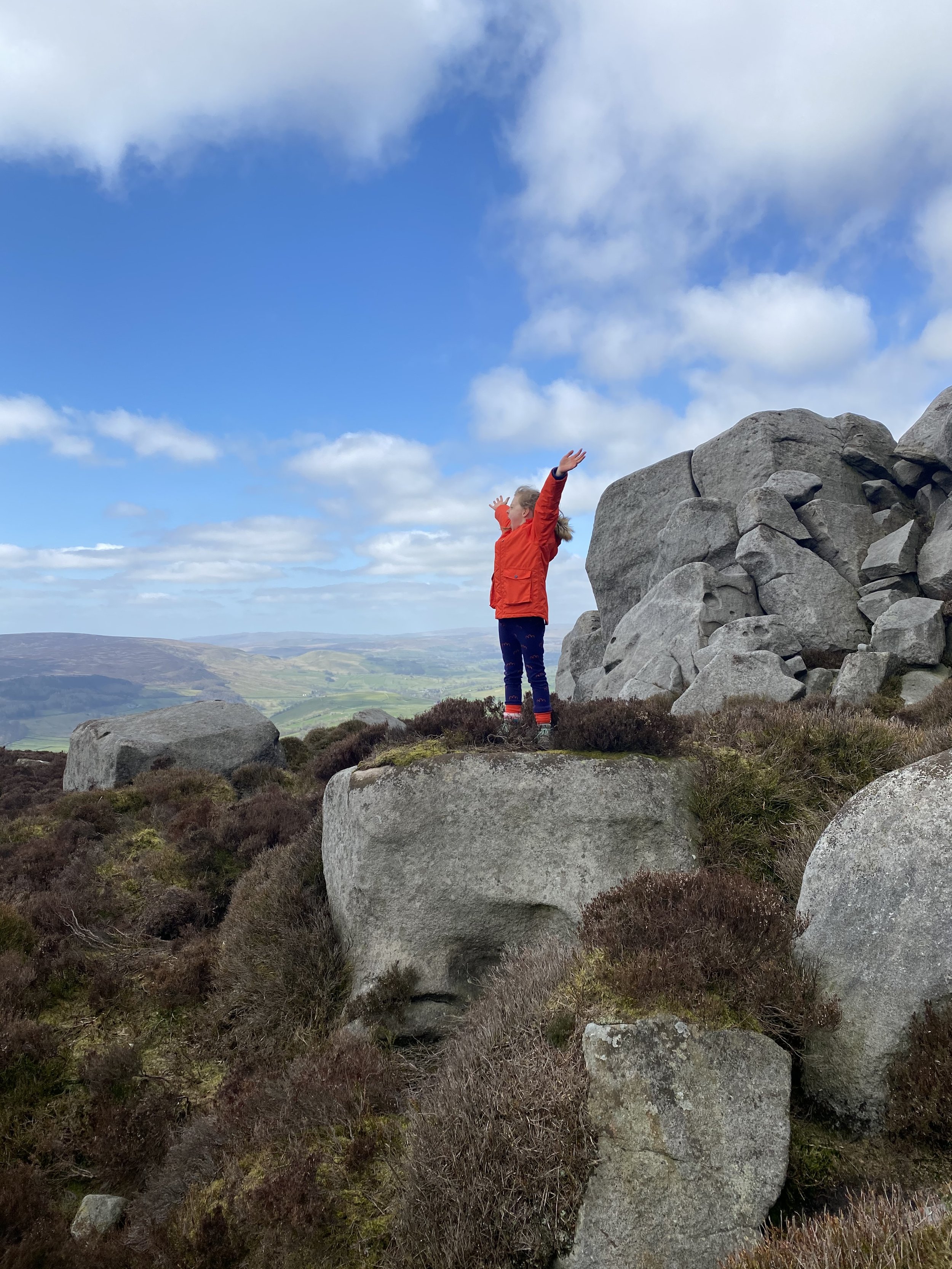
Looking towards the the left hand rocky outcrop of Simon’s Seat
Directions to Simon’s Seat
This walk heads out onto open fell, so take a map. These instructions are to provide additional guidance.
Bolton Abbey Estate Walks have clear route descriptions on the Bolton Abbey Website. There are also downloadable maps available from there. This description supplements that. We always recommend that you take a map and GPS with you, but this is even more important on the long walks! Good Lord, imagine if you had to turn back at do a section again! The horror….. the inevitable WHINGEING!
Beginning at the Riverside Car Park, head towards the Cavendish Pavilion (where you could treat yourself to a coffee and a cake) Cross the wooden bridge and follow the clear signage pointing you in the direction of the Valley of Desolation. Turn left at the end of the bridge and continue along the riverside to another gate. Here, turn right and head uphill towards the road.
Turn left onto the road, then soon there is a gate in the wall to your right. Go through this and head diagonally leftwards across the grassy field, onto a stone track and towards a metal gate.
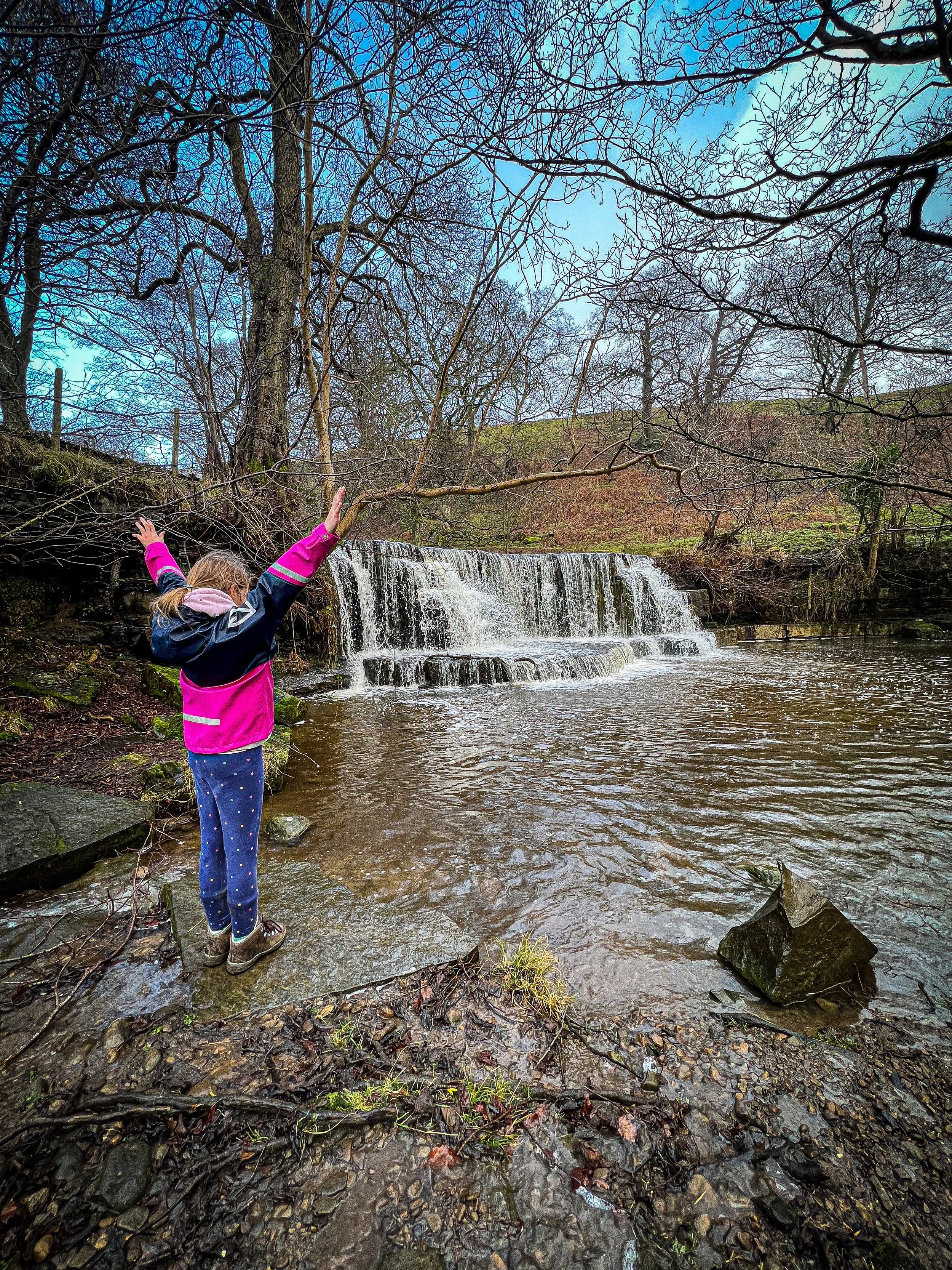
Go through this (there are often cows grazing here) and upwards along the track. It will take you past a pond on your right. Soon after this on your left (there is a bench at the top) there is a path that heads steeply down towards the spectacular waterfall on Posforth Gill. You can opt to take a detour to the waterfall at this point, or you can continue along the path you are on until you reach a wooden footbridge across the beck.
If you go to see the waterfall, head down the bank and cross the footbridge to the other side, and turn right. Shortly after crossing, there is a little path that shoots down to the right. This will get you to the edge of the waterfall for a closer look. Retrace your steps to the main track. The path to the right heads up the side of the waterfall, which you can follow, but be mindful there are some steep unguarded drops. Alternatively if you’d rather avoid it, retrace your steps back to the path you left to detour to the waterfall, turn left and continue to follow it to the wooden footbridge.
The path up the side of the waterfall continues to follow the beck upstream. You will pass a wooden footbridge to your right (don’t cross it, it’ll take you back where you came from) then the path rises leftwards towards the entrance of the large plantation (coincidentally, a top place to find pine cones and sticks!)
The path is wide, stony and very visible. Follow this through the plantation, until you reach the furthest perimeter, which will take you out onto the open moorland. Ahead of you to your right, you will see Barden Fell, to the left, Carncliff Top. In prolonged periods of dry weather, the moorland may also be closed to prevent the risk of fire. If in doubt, check before you head out!
Continue upwards on the wide moorland track. As you climb, you may notice a rocky outcrop to your right on Barden Fell. These are the Rocking Stones, and we took a little detour to go check out their climb-ability. They were given a thumbs up from the kids!
If you detour, double back on yourself to the path and keep heading up. The climb is pretty gradual. Keep going until you see the huge rocks to your right. Here, there is a pretty sizable and obvious path junction. Turn right. The terrain changes from rocky track to a wide well trodden path. You will be able to see the large rocks of Simon’s Seat up ahead.
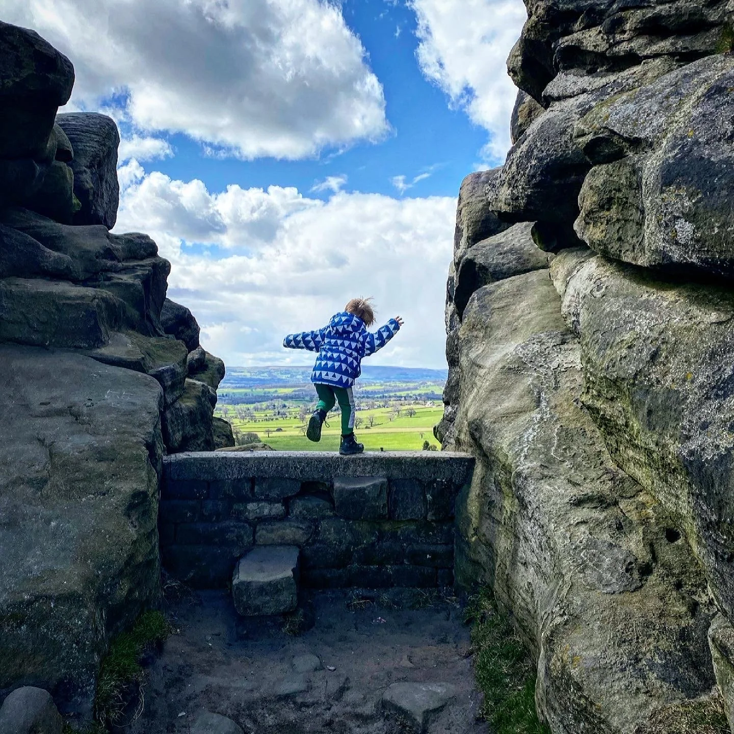
Once you have reached the impressive rocky outcrop, and clambered to your heart’s content, head to the Trig Point, which is situated on the topmost rock on the right of the mass of boulders.
To head back, you need to take the path in the direction of the Devil’s Apronful, ignoring the flagged pathway that goes in between the two rocky areas that takes you down to Dalehead Farm. Cast your mind back to the approach to the summit rocks. The right hand outcrop has the trig, the left hand pile has the path you need running directly in front of it, heading towards the Devil’s apronful in a south-westerly direction.
This will take you gradually downwards towards another plantation with mega views across the Dales to your right and ahead.
Once you reach the perimeter wall of the plantation, follow it for a short distance and then turn right onto the large wide zig-zagged track leading downwards through the trees.
At the bottom, you will emerge out of the trees and be treated to more spectacular views, as you descend towards Howgill. You need to take the path that heads straight on at the cross roads of paths at Howgill Lane. BUT FIRST, take a detour left to the Brownie Barn for brownies and ice cream, hot drinks or whatever else you fancy! Well worth a 5 minute detour. An impeccably placed cake bribery option!
Keep heading straight on, passing through the tiny Hamlet of Howgill, until you reach a road (Stangs Lane). The bridge over Fir Beck is to your right, and at this point, you need to carefully cross the road keeping to the left of the bridge and walking straight on through a small caravan site. This takes you to the edge of the River Wharfe. This path will be signposted The Dales Way, and it will veer left, and take you all the way back alongside the river until you get to Barden Bridge.
Thank the LORD, in warmer months, there is usually an ice cream van here, which will probably give you just enough ice cream energy to get you all the way back through the Bolton Abbey Estate!
Head back towards Bolton Abbey along the river. If you are here in the run up to Easter, at Halloween or at Christmas, there are seasonal trails running back alongside the river through Strid woods. Turn right at the Aqueduct (the big wide bridge) and then at the far end turn left. You are now on one of the well walked Bolton Abbey trails, simply follow this alongside the river, past the Strid and back to the Cavendish Pavilion! It serves drinks, snacks, cakes, and sandwiches and MORE ICE CREAM! I’m not sure about you, but if you’ve managed to get the kids all the way round Simon’s Seat, it’s definitely a well deserved double ice cream day!
Last walked March 2026

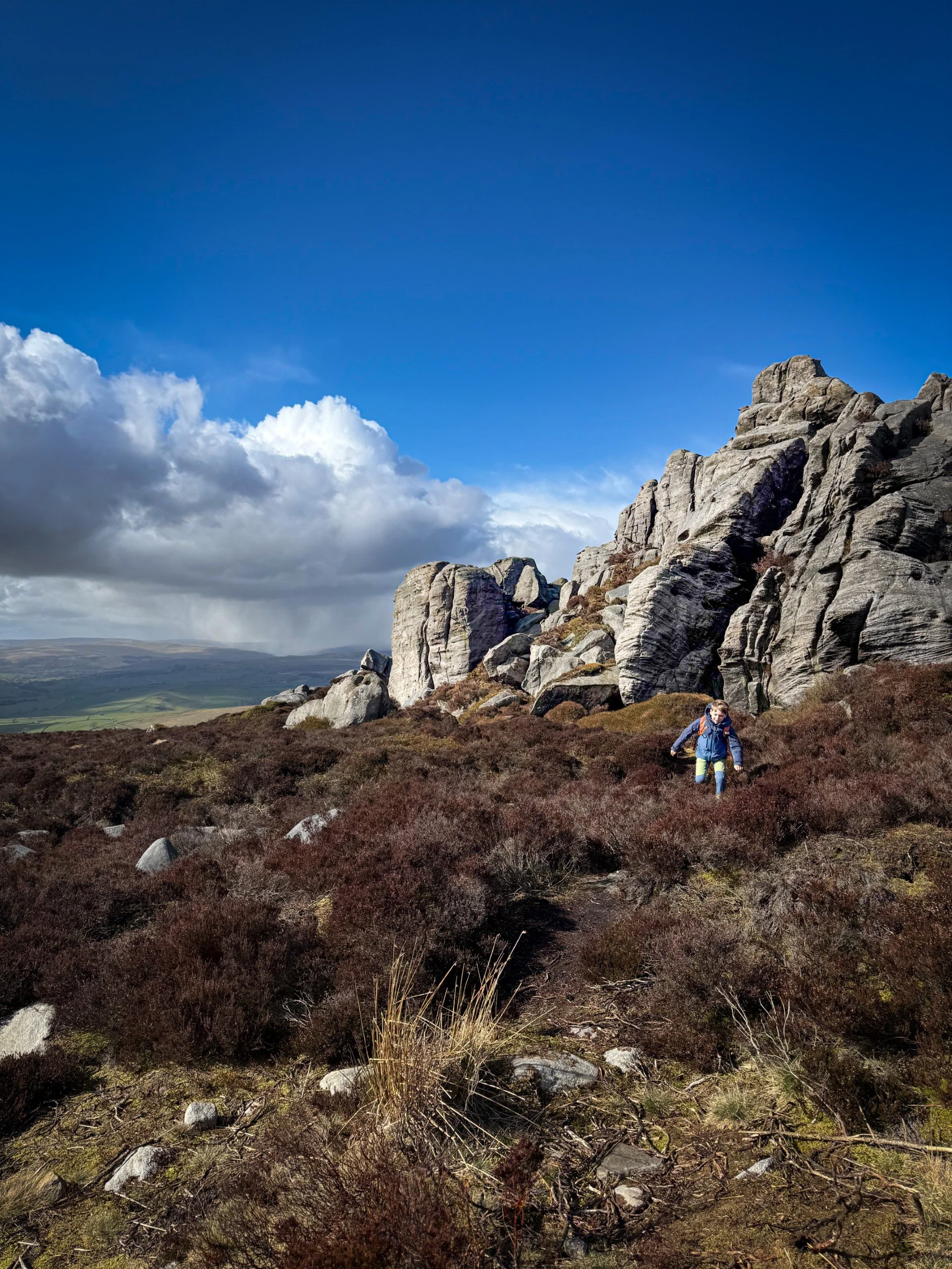
The views across to Wharfedale from the descent from Simon’s Seat
The view from the path down
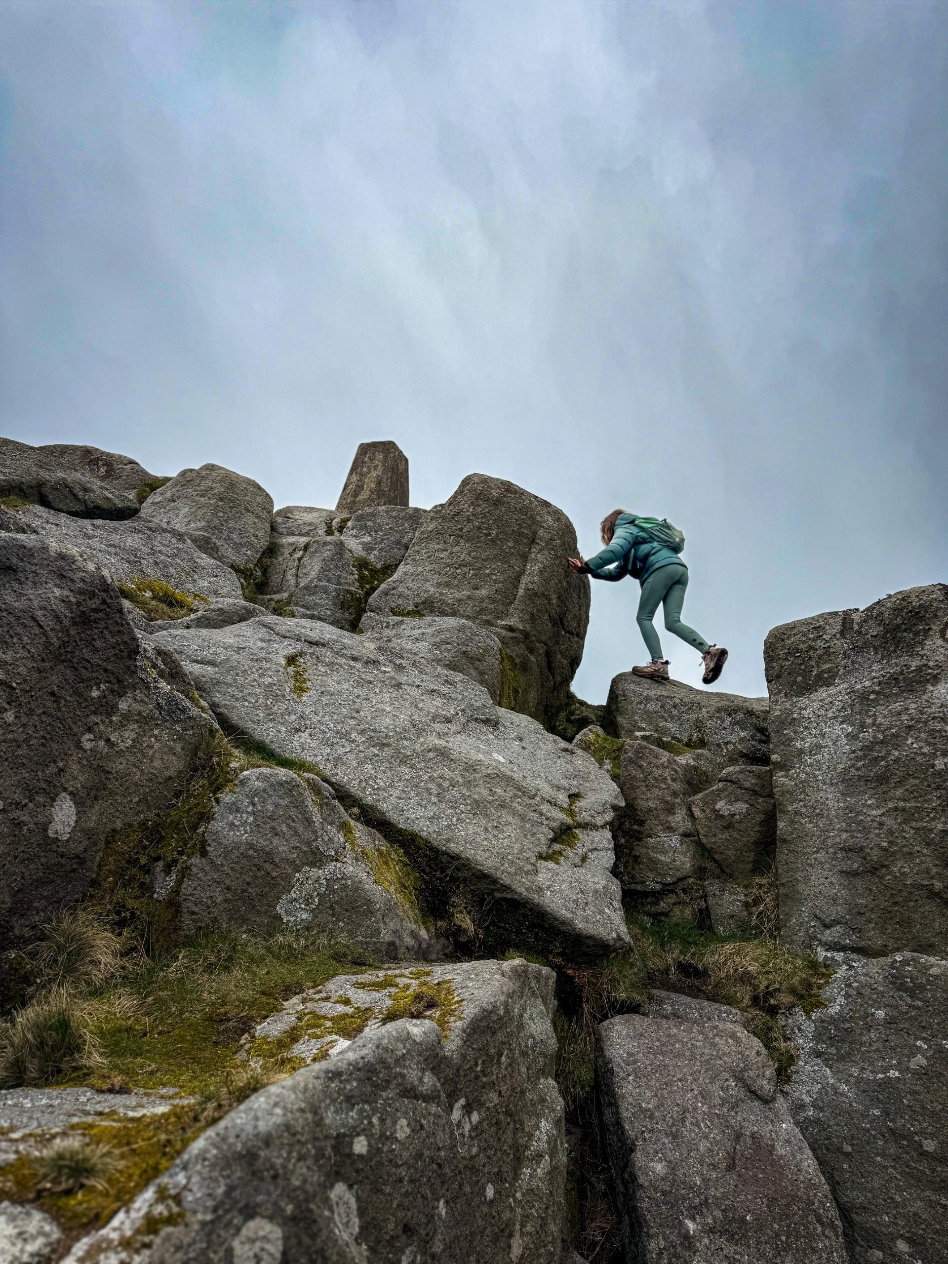
Clambering up to the trig point
⭐ We hope you enjoy our walks, but please exercise common sense as routes can change with the weather conditions and seasons! The routes have been walked by our own two feet, but you know your own limits. Always take a back-up map, don’t rely on GPS alone, wear appropriate clothing for the weather and take adequate snacks and refreshments with you (although as a parent, I know you already know that bit!)
⭐ Leave no trace! Take nothing away and leave nothing behind, take all rubbish home with you.
⭐ If you choose to paddle, be aware of bio security. Always wear clean dry water shoes (if worn) to avoid cross contamination of species between watercourses, this is a particular issue in the Yorkshire Dales, to help protect the white clawed crayfish.
⭐ If you decide to paddle, be aware that wild water can be dangerous, and water levels will vary season to season. Always supervise children around water. Check out the safety information on the Royal Life Saving Society website.
For more information visit our helpful tips and advice page

Crucially, this is NOT the Strid! Read on to see why…
What’s cool for kids on this walk?
☕ One for the grown ups here. The Cavendish do a fabulous coffee, tea, hot chocolate, whatever takes your fancy! Many a day has a stroll along the Strid been accompanied by a steaming brew!
🏰 During the Summer there is a large sandpit located near the start of the trail through Strid Wood.
🧚Love a bit of folklore? The Strid at Bolton Abbey is a stretch of the River Wharfe that is one of the most deadly in the world. The entirety of the Wharfe is squeezed into a narrow rocky channel that is so narrow it looks like you could simply step over it! Which is exactly why it’s called The Strid. The word is derived from Stride, but almost certainly do not do any stepping near the edge! The Strid has claimed several lives in the past because if you fall in, you aren’t coming back out again. What lies beneath the churning water is an unknown depth (literally nobody has managed to reliably measure it) there are rocky shelves, carved out holes, and a torrent of river so fierce it will literally suck you under.
Have I terrified you? Then it’s no wonder that there are legends attached to The Strid, one of a deadly fairy and a kelpie (a water horse) who rides out of the water to claim their victims…
But in all seriousness, there is a safe viewing platform from which you can view the Strid on your return route without fear of being taken by any creepy fairies and their horses! Like a bit of folklore? I’ve written extensively about the Folklore of the Dales in our Folklore walks!
💦 There are points where you can get down to the water to throw some stones in the river and paddle.
🌳 During the Easter Holidays, Halloween Break and Christmas, the Strid is home to seasonal trails! If you are visiting out of season, then why not try one of our walking games? Or you can download a free scavenger sheet!
Want to grab the route?
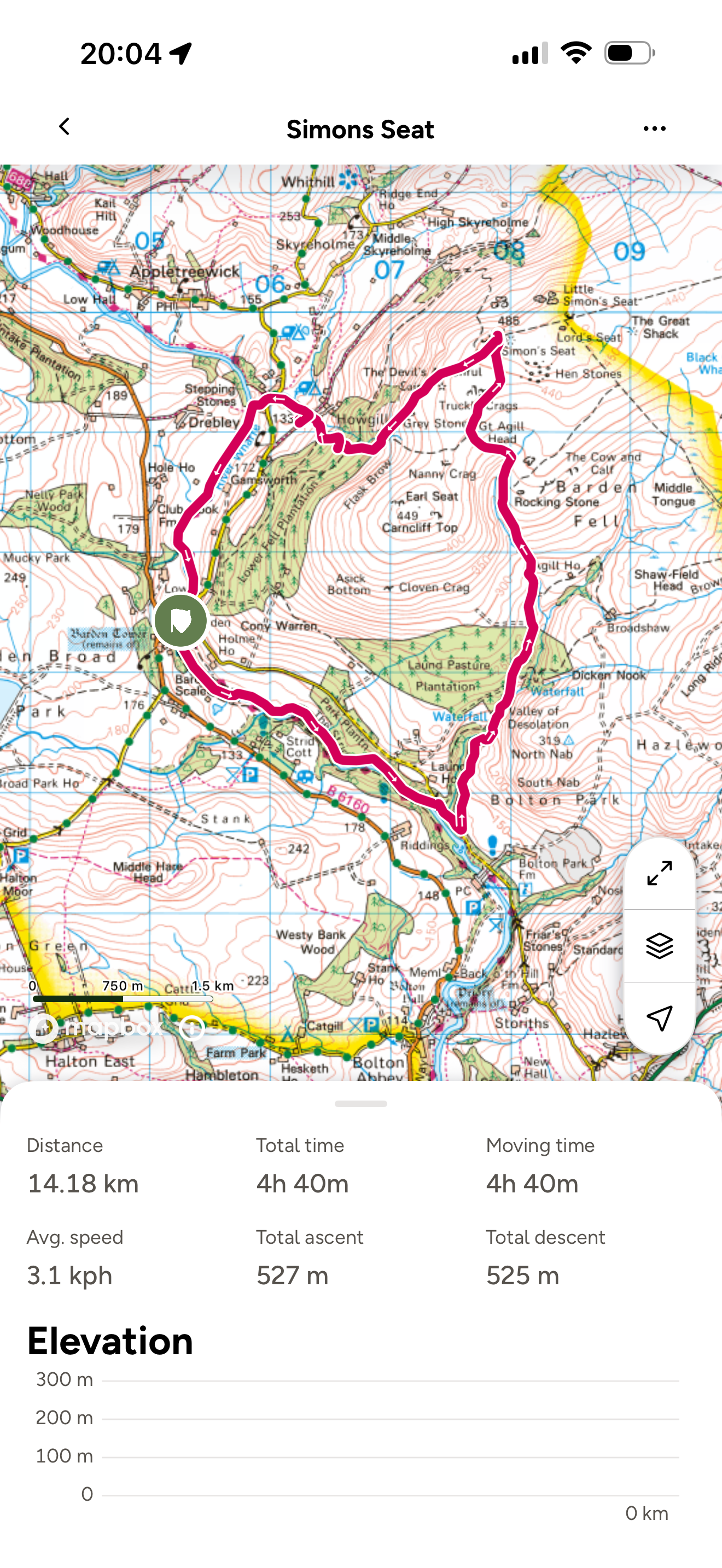
Head to the Ordnance Survey Navigation App where you can download the route! Here’s our route. On this occasion we managed to get parked at Barden Bridge which was the start point. If you manage to get parked there simply follow the route instructions from the end first, then cycle round to the start!
(Always carry a back up map and know how to use it)
Image is Copyright of Ordnance Survey
Want more Yorkshire Dales walks?
We have loads of family friendly walks in and around the Yorkshire Dales, so make sure to head over to our Yorkshire Dales page to find out more!
Scroll using the arrows for all our Family Friendly Walks
-
![Swimming in Janet's Foss Yorkshire Dales]()
Waterfall Walks
-
![Malham cove walk for kids]()
Pushchair Friendly
-
![Pinhaw Beacon trig point walk near Skipton]()
Peak Bagging Walks
-
![The Park at Greenhow Nidderdale]()
Walks with Play Parks
-
![Gordale Scar in Malham Yorkshire Dales]()
Organised by Location
-
![Walking in the woodland in Wensleydale]()
Woodland Walks
-
![Playing on the shore of Embsay Reservoir Yorkshire Dales]()
Reservoir Walks
-
![The ruins of Bolton Abbey]()
Bolton Abbey Estate Walks
-
![Leaping over the stile at Almscliffe Crag]()
Walks Under 2 Miles
-
![Child walking into a pub in Appletreewick]()
Walks with Pubs and Cafes


Follow us for up to date Outdoors Adventures!
We live and BREATHE the Yorkshire Dales outdoors life!
Come follow our journey over on Instagram and Facebook where you’ll find up to date walk info, breaking news on Yorkshire Events, new Yorkshire Dales wild swim spots, climbing, caves and more!


Follow us on Social Media for all the up to date info: @thereluctantexplorers
Leave No Trace
The Yorkshire Dales is our home, and the home of so many others who care deeply about this beautiful space.
Should you visit, make sure to:
Take home anything you bring, leave no rubbish behind.
Make the world a better place by picking up any rubbish you see, even if it isn’t yours.
Leave everything else as you found it.